
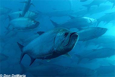
Atlantic tarpon
The “Silver King” is prized as a powerful catch-and-release sport fish and is found in bays, passes, rivers and canals.
Species profile ↗The complete topic is displayed directly below.
Save the places worth visiting—and the official rule links worth checking—before you leave the dock.
These reference photographs sit with the fishing information below. Identification and current FWC regulations should always be independently confirmed.
The “Silver King” is prized as a powerful catch-and-release sport fish and is found in bays, passes, rivers and canals.
Species profile ↗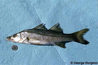
Recognizable by its dark lateral line, snook favor mangroves, river mouths, shorelines and estuarine habitat.
Species profile ↗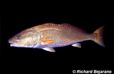
Red drum tolerate varied salinity and commonly use estuaries, river mouths, seagrass beds and shallow coastal water.
Species profile ↗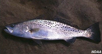
Often associated with grass flats, sandy bottoms and estuaries, this species has black spots across its upper body and fins.
Species profile ↗Call ahead for dock availability, operating hours, maximum vessel size and temporary closures.
458 Tudor Drive, Cape Coral
42 dock-and-dine slips at Bimini Square
5785 Cape Harbour Drive #106
Cape Harbour waterfront dining
5785 Cape Harbour Drive #102
Seafood near Cape Harbour docks
5785 Cape Harbour Drive
Coffee, breakfast and gelato by the marina
6095 Silver King Boulevard
Tarpon Point waterfront dining
5991 Silver King Boulevard
Seafood and marina views
5951 Silver King Boulevard
Westin waterfront restaurant
6179 Black Marlin Lane · gas, diesel and pumpout.
239-549-49005828 Cape Harbour Drive · marina services and fuel. Confirm transient and fuel hours.
Marina information ↗2628 SE 26th Place · saltwater access; paid trailer parking.
City ramp information ↗Inventory and hours change. Call a nearby marine or tackle shop before trailering across town.
Find current shops ↗Regulations can change by region and emergency order. Verify the FWC page and Fish Rules app on the day you fish.
Tarpon, snook, redfish, spotted seatrout, sheepshead, black drum, mangrove snapper, jack crevalle, ladyfish, pompano, permit, flounder, Spanish mackerel and several shark and ray species.
Tarpon, cobia, tripletail, king mackerel, Spanish mackerel, snapper, grouper, barracuda, bonito, sharks and seasonal pelagic visitors. Reef and federal-water rules may differ.
Largemouth bass, bluegill, redear sunfish, crappie, catfish, tilapia, Mayan cichlid, oscar, peacock bass in some connected South Florida waters, and other native or nonnative species.
Similar-looking species can have different limits. Sharks, sawfish, sturgeon and other protected or prohibited species require special handling or immediate release. Photograph uncertain fish and consult FWC identification resources before keeping anything.
Always confirm current rules: FWC Saltwater Recreational Regulations · FWC Freshwater Regulations · Licenses and permits
Resident and nonresident requirements differ. A no-cost resident shoreline license does not cover fishing from a vessel. Age and residency exemptions exist, while some activities and species require additional permits or designations.
Buy or verify a licenseCape Coral does not have one guaranteed canal depth. The controlling depth can occur at the dock, within the canal, at a turning basin or canal mouth, on the spreader approach, or before the marked Caloosahatchee channel.
Cape Coral says its current maintenance permits do not allow dredging deeper than five feet below mean low water. That is a maximum permitted dredging depth—not a promise that every canal currently has five feet of water.
The U.S. Army Corps describes the 155-mile Okeechobee Waterway, which includes the Caloosahatchee River, as having a maintained-depth range of eight to ten feet. Local shoaling and notices can reduce available depth.
A deep main channel does not make the route usable if the dock pocket, residential canal or canal-to-river approach is shallower than the boat’s loaded draft plus a prudent safety margin.
Measure beside the lift and along the boat’s departure line at a representative low-water condition. Include the vessel’s true loaded draft, drive, skeg and required under-keel clearance.
Sound the intended path, bends and turning basin—not only the center behind the house. Sediment, storm deposits, prop wash and bank erosion create uneven bottoms.
Check the canal mouth, spreader connection and river approach for shoaling. These transition areas can be shallower than either the canal center or the marked river channel.
Use the latest NOAA electronic chart, channel markers and U.S. Army Corps notices. Charted or maintained depth does not guarantee the same depth outside the marked channel.
These are trip ideas—not turn-by-turn navigation. Distance, running time, fuel range, bridge and wire clearance, depth, tides, weather, dock access and no-wake zones must be verified for the boat and route you will actually use.
An Old Florida island stop near Intracoastal Waterway marker 60, accessible only by boat. Call ahead for restaurant hours and transient dock conditions.
Cabbage Key official site ↗A boat-access state park with remote Gulf beaches. Private-vessel day access is posted from 8 a.m. to sunset; confirm current facilities, fees and closures before departure.
Cayo Costa conditions ↗Cruise north through Pine Island Sound toward Gasparilla Island. Plan dockage before leaving and verify local channels, tides and Gulf conditions.
Gasparilla Island State Park ↗A car-free island reached by boat. Arrange legal dockage or a reservation with your destination—private docks and club facilities are not automatically open to day visitors.
North Captiva visitor guide ↗A classic Pine Island Sound outing for beaches, wildlife and waterfront stops. Confirm marina space and current island access rather than assuming beach-side anchoring is permitted.
Sanibel Marina ↗Head toward Matanzas Pass for waterfront dining and beach time. Reserve dockage, review the return weather window and allow extra time for marked no-wake areas.
Fort Myers Beach information ↗Key West Express boards at 1200 Main Street, Fort Myers Beach—not at a Cape Coral dock. Travelers arrange their own transportation to the terminal, park and board the passenger catamaran. The operator currently lists 7 a.m. boarding, required boarding by 7:30 a.m. and an 8 a.m. departure from Fort Myers Beach, but schedules vary by season and conditions.
File a float plan with someone ashore, check marine weather and tides, carry required safety gear, preserve a fuel reserve and know when to turn back. Gulf and Pine Island Sound conditions can change faster than the view suggests.
Rental inventory, rates, deposits, operator credentials, departure points and weather policies change. These listings are provided as starting points and are not endorsements; independently verify every operator and agreement.
Powerboat rentals from Cape Harbour, with dock delivery offered for qualifying multi-day rentals. Reservations are recommended.
Marina-based boat, kayak and paddleboard options plus private or group charter information. Call for current inventory and requirements.
Cape Harbour departures include dolphin, nature, homes-and-harbor and sunset experiences. Tour lengths and departure times vary.
Port Sanibel departures include dolphin and wildlife cruises, shelling trips, sunset cruises and private charters. Reservations are required.
Confirm what is included, cancellation and damage terms, security deposit, insurance, fuel policy, geographic limits, towing coverage, minimum operator age and whether Florida boating-safety identification is required. For cruises or charters, confirm the vessel, captain’s credentials, passenger capacity and weather-refund policy.
Florida boating-safety ID requirements ↗The Koffman Waterfront Route Finder reports mapped fixed-bridge clearances. It does not report the height of electrical conductors.
No authoritative public citywide inventory of Cape Coral canal-crossing power-line locations and measured vertical clearances could be verified through the City or LCEC. For that reason, this guide does not estimate a wire height or place an unverified crossing on the map.
Before navigating a specific route, identify every visible overhead crossing, know the boat’s full air draft—including antennas, outriggers, T-top or mast—and obtain current route-specific guidance. Water level, wire sag, temperature and utility work can change the available margin.
Save the traditions that make waterfront life memorable. Dates, routes, admission, registration and weather plans can change—always confirm with the official organizer before going.
A two-day benefit with a captain’s dinner, inshore tournament and awards dinner. Teams target one snook, one redfish and one trout under the published tournament rules.
Official event details ↗A Lee County tarpon tournament benefiting Folds of Honor. The organizer has posted May 28, 2027 as the next tournament date; registration and angler details should be confirmed directly.
Official event details ↗Two weekends of live bands, German food, dancing, festival tents, a biergarten, crafts and family activities. The organizer’s 2026 schedule is still being finalized.
Official event details ↗A free holiday weekend with tree and menorah lighting, food trucks, vendors, ice skating, movies, Santa and a Saturday-night drone show.
Official event details ↗Cape Coral’s lighted holiday boat parade includes entertainment, food trucks, crafts, Santa and an outdoor movie. Boat-parade registration is coordinated through Sea Tow at 239-945-4820.
Official event details ↗More than 200 artists and craftspeople, student art, a business showcase and food vendors fill the Parkway for one of Lee County’s largest annual events.
Official event details ↗Cape Coral’s free Independence Day celebration takes place at the foot of the Cape Coral Bridge with live entertainment, family activities and fireworks over the Caloosahatchee River. The 2026 celebration began at 5 p.m., with fireworks scheduled around 9:30 p.m. Future-year schedules, bridge closures, shuttles and boating restrictions should be verified when the organizer posts them.
Check Red, White & BOOM updatesObey idle-speed zones, wear polarized glasses, avoid shallow grass and never pursue or feed them.
Never feed wild dolphins; it changes behavior and can put them near hooks and propellers.
Give nesting areas wide clearance, keep beaches clean and use wildlife-friendly lighting.
Expect them in freshwater canals. Never feed or approach them; keep pets away from the bank.
The beach area is part of an active redevelopment setting. Check City access and construction updates before going.
Bay and Gulf access with paid parking; pier status and access can change.
Beach, paddling and wildlife; open 8 a.m. to sunset unless posted otherwise.
Remote island beaches. Private-vessel access resumed with limited services; verify ferry, camping and facility status.
Shallow bay beach popular for paddling, shelling and birding.
Verify access and park conditions before departure: Cape Coral Yacht Club · Cayo Costa · Lovers Key
Send Steve the address and your boat details. He can help you evaluate access, bridges, seawall, elevation and due-diligence questions before you commit.